Research
RESEARCH AT UPHAM WOODS
A wealth of knowledge has been generated by researchers that come to Upham Woods, both in natural sciences and human sciences. Over the last several decades, researchers have published almost 50 scientific journal articles that have cumulatively been cited over 6,600 times. Much of the past research done at Upham Woods used remote sensing technology to answer questions about forest ecosystems, ranging from the chemical makeup of roots and leaves to nutrient cycling in the forest canopy.
Why Conduct Research at Upham Woods?
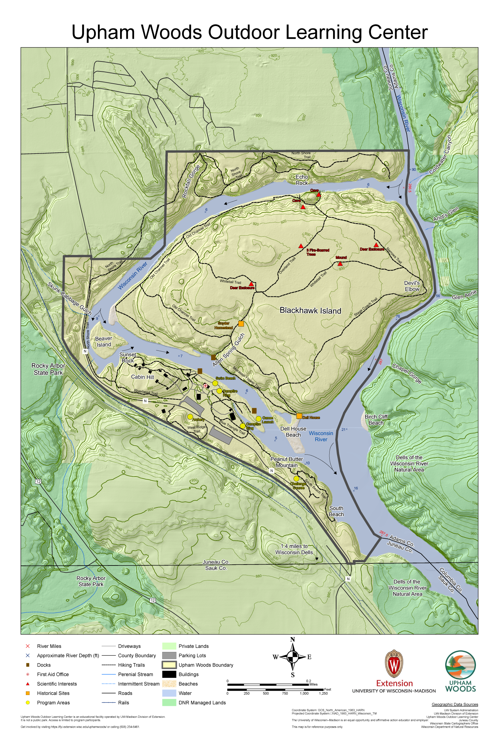
Upham Woods is an outdoor learning center operated by the University of Wisconsin – Madison Division of Extension under the Natural Resources Institute. Located 2 miles north of the Wisconsin Dells on the Wisconsin River, the center rests on 320 acres of forested land including a 210-acre state natural area (#77) called “Blackhawk Island.” Home to both southern and northern plant communities, Blackhawk Island hosts multiple microcosm transitions of forest community types dominated by 1) red oak, white pine, and white oak 2) red and white pine with some red oaks 3) red oak, white oak, sugar maple, and basswood 4) hemlock with some yellow birch and white cedar 5) white oak, white pine, and red maple 6) river birch, cottonwood and red maple. Big tooth aspen is dominant in two small areas which were once logged and plowed for field crops. On the north shore property, Skunk Cabbage Gulch, Rockfall Gorge, and Spring Gulch contain some of the most interesting vegetation, including ⅓ of the state’s known fern taxa. The campus includes over 4.5 miles of shoreline along the Wisconsin River with access to a diversity of stream ecologies (Wisconsin River “broads,” “narrows,” impoundments, and sloughs). The campus includes over 7 mile of trails, 0.5 miles of which is paved. Upham Woods provides an ideal setting as a long-term ecological research site to conduct large-scale, ecosystem-wide projects in stream ecology, forestry, soil science, botany and limnology.
Current Research
Soil Aggregate Study
Gwendolyn Pipes
PhD Candidate
Department of Soil Sciences
UW-Madison

Surveillance for Ticks and Vector Bourne Diseases
Dr. Xia Lee
Vector Biologist
Midwest Center for Excellence: Vector Borne Disease

Explore Research Opportunities
Unique Features- Flora and Fauna
Differences in forest types on the Island can be observed when following the Overland or Narrows Trail to the north and northeast side of the Island, where the habitat changes from Dry-Mesic forest to Hemlock Moist Forest. Several distinct ecosystems are found on site, including:
Prairies: on sandbars and old river channel banks and on small prairie patches on the rim of the sandstone bluffs overlooking the river. Most of the species here have western affinities;
Southern Dry-Mesic Forest: upland forest community with loamy soils dominated by Red Oak, White Oak, Basswood, Sugar Maples and Red Maples. Characterized by a diverse understory including ferns and spring ephemerals;
Northern Dry- Mesic Forest: white, red, and jack pines, growing on about three sides of the island with occasional mixing of Red Oak, Red Maple, Sugar Maple, Paper Birch, and Aspens. Shrubby understory with sandy or loam soils;
Maple Woods: on top and in the center of the island, very rich in species of mesophytic herbs, mainly with southern affinities;
Hemlock Relict Forest: on rocky sandstone cliffs, slopes and ravines overlooking the Narrows of the Wisconsin River on the north and east sides of Blackhawk Island dominated by Eastern Hemlocks, White Pine, Yellow Birch and Paper Birch. Ferns and club mosses dominate ground layer, although often sparse due to the lack of light reaching the ground;
Dry Cliff Communities: on the northern and east sides of the island on the exposed Cambrian sandstone gorges flanking the Wisconsin River. Where wooded, they are cool and moist offering habitat for many ferns and boreal species. On the level of the cliffs are a number of typical bog species such as Gaylussacia baccata, the huckleberry, and Ledum groenlandicum, Labrador tea, which are able to grow there, high and dry due to the pronounced acidity of the sandstone.
Upham Woods BioBlitz 2018 Results
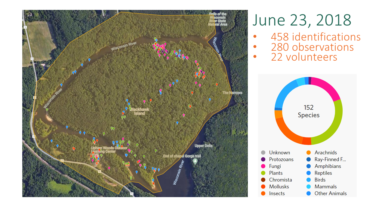
View all iNaturalist Species Observations at Upham Woods
Fauna of Blackhawk Island
Birds
- American Crow
- American Robin
- Bald Eagle
- Turkey Vulture
- Barred Owl
- Black-capped chickadee
- Black-throated Green Warbler
- Blue Jay
- Blue-gray Gnatcatcher
- Blue-winged Warbler
- Brown-headed Cow Bird
- Chipping Sparrow
- Crested Flycatcher
- Hairy Woodpecker
- Louisiana Waterthrush
- Mallard
- Wood Duck
- Mourning Warbler
- Northern Oriole
- Ovenbird
- Pheobe
- Pileated Woodpecker
- Red-headed Woodpecker
- Pine Warlber
- Red-bellied Woodpecker
- Red-tailed Hawk
- Red-breasted Nuthatch
- Rose-breasted Grosbeak
- Rough-winged Swallow
- Scarlet Tanager
- Song Sparrow
- White-breasted Nuthatch
- Wood Pewee
- Red-bellied Woodpecker
- Red-tailed Hawk
- Red-breasted Nuthatch
- Rose-breasted Grosbeak
- Rough-winged Swallow
- Scarlet Tanager
- Song Sparrow
- White-breasted Nuthatch
- Wood Pewee
Mammals
- Coyote
- Red Fox
- Red Squirrel
- Ground Squirrel
- Gray Squirrel
- Whitetail Deer
- Common Shrew
- American Beaver
- North American River Otter
- Groundhog
Amphibians and Reptiles
- American Toad
- American Bullfrog
- Green Frog
- Grey Tree Frog
- Common Garter Snake
- Eastern Hognose Snake
Insects & Arachnids
- Eastern Tent Caterpillars
- Polyphemus Moth
- Black Giant Ichneumonid Wasp
- Eastern Giant Swallowtail Butterfly
- Forked Fungus Beetle
- Isabella Tiger Moth
- Easter Tiger Swallowtail Butterfly
- Spine-headed Bug
- Horn Spanworm Moth
- Milkweed Tussock Moth
- Pleasing Fungus Beetle
- Stream Bluet
- Pale Green Assassin Bug
- Yellow Slant-Line
- Stygian Shadowdragon
Mollusks
- Fatmucket
- Wabash Pigtoe
Fungi:
*Only those identified to species
- Artist’s Bracket
- Orange Peel Fungus
- Collared Parachute
- Mossy Maze Polypore
Unique Features- Geology & Hydrology
Upham Woods is an ideal place to study the geology of the Central Sands Plains of Wisconsin. The sandstone cliffs that make up the Dells of the Wisconsin River were formed about 510-520 million years ago during the Cambrian Period, from deposition of windblown sand dunes. No deposits are known for the interval between 500 million years ago and the last glaciation of Wisconsin (~20,000 years ago), when the Laurentide Ice Sheet flowed southward over the east end of the Baraboo Hills to within 3 miles of the Upper Dells. About 15,000 years ago, an ice front dammed the Wisconsin River to form Glacial Lake Wisconsin, which drowned the Dells with up to 150 feet of water over an area stretching nearly to Wisconsin Rapids. About 14,000 years ago, the ice dam failed and the lake drained rapidly southward, carving the network of narrow, steep-sided canyons visible today.
Today the hydrology of the river is heavily influenced by the operation of the Castle Rock dam, approximately 14 miles upriver from the Upper Dells, and the Kilbourn Dam, located within the City of Wisconsin Dells. With the construction of the Kilbourn Dam in 1909, the water level was raised ~16 feet, filling the old channel and forming Blackhawk Island. Both of these dams are operated on a peaking basis. The river is known for its strong swirling currents that deposit sands which form, erode, and submerge sandbars along the river corridor.
Upham Woods is located in the Dell Creek Watershed of the Lower Wisconsin River Basin, which drains approximately 4,940 miles of south central and southwestern Wisconsin. Agriculture is the predominant land-use in this watershed. The Upper Dells region of the river reaches a maximum depth of ~100 feet and a width of 52 feet at Devil’s Elbow.
Unique Features- Soils of Blackhawk Island
Depth through the soil to the underlying sandstone is approximately 1 meter across the top of the island except on the two knolls where the soil is thinner. There are two river terraces on the west end of the island, one higher and older than the other. Both are composed of sandy alluvium. The material across the top of the island, and within which the soils have developed, grades from loams and sandy clay-loams on the west, north, and south to the silty clay-loams slightly to the east of center of the island. Silt loams cane be found on the northern and eastern edge of the island at the break in slope before the sand stone cliffs. Sometimes a thin, 4-10 cm, layer of sand and sandstone cobbles is sandwiched between soil profile and the bedrock; more often, the soil lies directly on top of the bedrock. The boundary between the soil and the sandy layer or bedrock is sharp throughout the top of the island and no sandstone cobbles or psuedomorphs are found in the profiles (Pastor, et al., 1982).
The soil of the youngest and lowest terrace, located below the cliffs near the western side of Blackhawk Island, is a Typic Udipsamment (Entisol). Buried forest floor in the profile attest to the flooding and deposition by the river. The soil of the older terrace, located above the cliffs, is an Entic Haplorthod (Spodosol), a soil rare in southern Wisconsin but common in northern Wisconsin. Soils across the top of the island, expect for soils on the sandstone knolls, are all Typic Hapludalfs (Alfisols), the most common of the region. The soil on the larger of the two knolls is Typoic Dystrochrept (Inceptisols), a soil midway in development between the sandy Entisol of the youngest terrace and the remaining Alfisols. Soils not on the main transect (see figure below) include Folists (Histosols) on cliffs and plowed Alfisols near the center of the island. The soil on the smaller of the two knolls in also a Folist. The silt and clay content of the soil increases steadily across the island from west to east following the main transect (Pastor, et al., 1982).
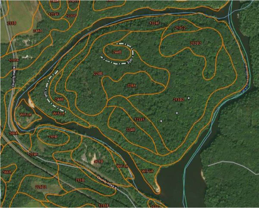
Soil characteristics of Blackhawk Island and the surrounding area. The following describes the symbols and soil characteristics of the map.
- 1224F: Boone- Elevasil complex, 15-50% slope
- 1233F: Boone- Tarr sands, 15-50% slope
- 202B2: Lambeau silt loam, 2-6% slope, moderately eroded
- 213B2: Hixton silt loam, 2-6% slope, moderately eroded
- 213C2: Hixton silt loam, 6-12% slope, moderately eroded
- 224B: Elevasil sandy loam, 2-6% slope
- 228A: Partridge loam, 0-3% slope
- 224B: Elkmound loam, 2-6% slope
- 561B: Tarr sand, 1-6% slope
- WiFoA: Winterfield-Fordum comlec, river valleys, 0-3% slope, frequently floods
Boone- Elevasil complex: sand and weathered bedrock that drains excessively, medium runoff class
Boone-Tarr sands: sand and weathered bedrock that drains excessively, high runoff class
Lambeau silt loam: silt and sand at the tops of hills, well drained
Hixton Silt loam: silt, well drained
Elevasil sandy loam: sandy loam, well drained, low runoff class
Partridge loam: depressions on hills, loam over sand, poorly drained, very low runoff class
Elkmound loam: Ridges, loam, well drained
Tarr sand: sand, excessively drained, found as pediments near other formations
Winterfield-Fordum complex: Flood plains, backwaters and related sediments, loamy sand over san, poorly drained
Unique Features- Location
Upham Woods is centrally located, only 1 hour north of Madison, 2 hours northeast of Milwaukee, 1 ½ hours southeast from La Crosse, 1 ½ hours south of Stevens Point, 2 hours southeast of Eau Claire, and 2 ½ hours southwest of Green Bay. We are ½ hour drive or less from Devil’s Lake State Park, Mirror Lake State Park, and Rocky Arbor State Park. Upham’s campus lies adjacent to the Dells of the Wisconsin River State Natural Area. We are a mere 20 minute drive from the International Crane Foundation and the Aldo Leopold Foundation, home of the Leopold shack.
We welcome visits to Upham Woods; however, under the deed by which the land was donated to the University of Wisconsin, we are a private facility that cannot operate as a public park. This means you must have permission to be on site. Please call 608-254-6461 or email uphamwoods@extension.wisc.edu if you wish to arrange a visit to the campus.